Category Archives: Beached Birds

Grebe Time

COASSTers surveying along the Lower 48 West Coast know that winter brings cold, darkness, rain… and grebes. This winter season, COASST has received a flurry of messages about an uptick in beachcast grebes. Is this normal? Is something going on? The answers are yes, and yes.

Grebes breed inland on freshwater lakes and ponds throughout western North America, migrating to coastal locations post-breeding from the Gulf of Alaska south to Mexico, and including inside waters like the Salish Sea, San Francisco Bay, and the Gulf of California. By November, the chance of encountering a grebe along the Pacific Northwest outer coast has risen from essentially zero to about one grebe per 5 kilometers. And that’s the average, some places and some years see much higher spikes.

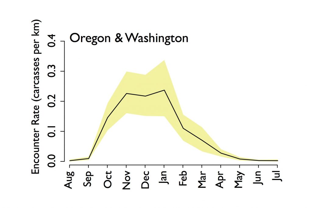
The black line traces the average or “baseline” pattern of how many grebes are found per kilometer of beach length over the year (where numbers less than one mean you would need to walk more than a kilometer to find a grebe). The yellow area to either side of the line is the range over which 95% of the actual variability in that central signal lies. If we record a month and year that is absolutely lower (or higher) than the yellow area, we pay attention.

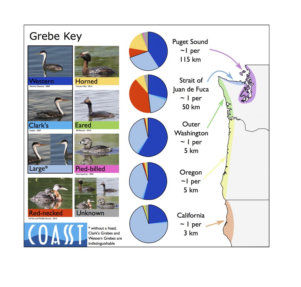
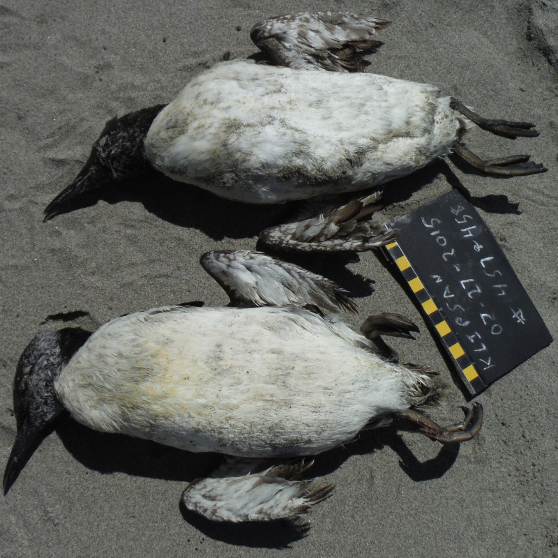
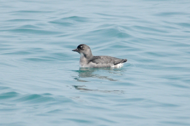
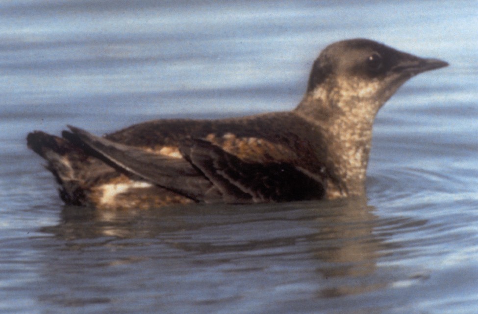
Most of the grebes washing ashore on COASST beaches are large grebes, and most of those are Western Grebes. The pie charts in the map graphic indicate the proportion of grebes found in each region identified to species. Dark blue is Western, turquoise is Clark’s, and light blue is when we can’t tell the difference.

What?!? Are we really that bad at identification? Nope. Turns out that a headless large grebe is impossible to differentiate as Western or Clark’s. And that’s because the best character is whether the dark|light plumage line on the face puts the eye in the dark feathers (Western) or the white feathers (Clark’s).

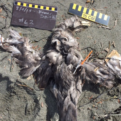
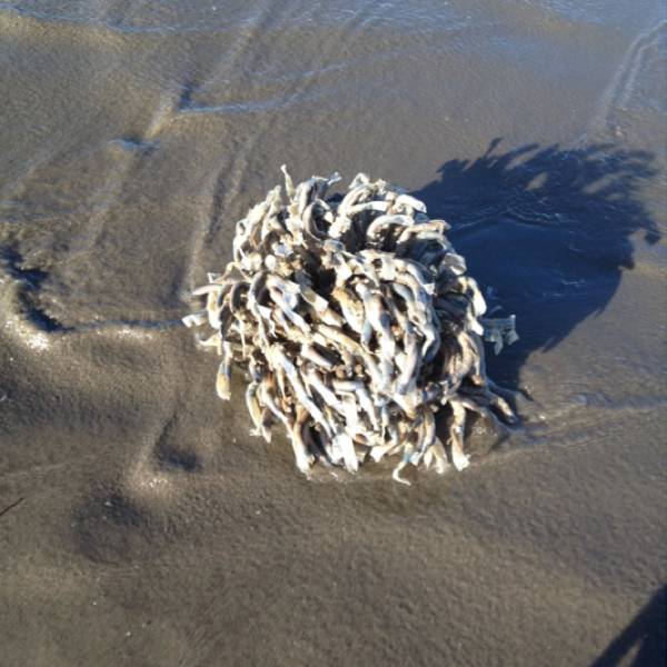
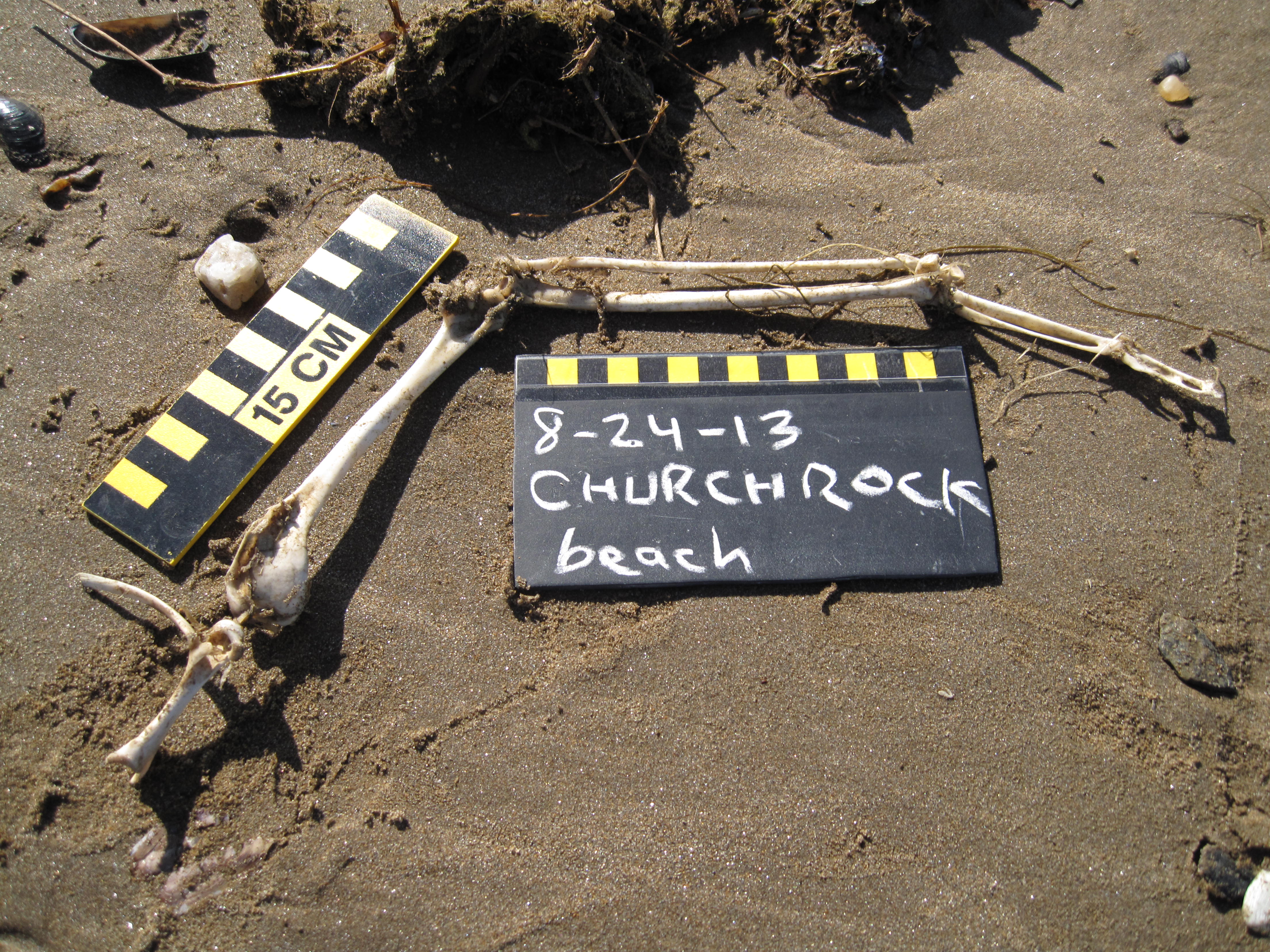
Side note: headless grebes, or more commonly a grebe with the neck skin inverted and pulled over the face so that only the bill is poking out from this macabre inside out turtleneck are the victims of raptors who literally skin their dinner to expose the breast meat. Light blue pie slice? – that’s a raptor signal.

There are several really cool patterns to note in this graphic:

  • First, the proportion of the grebe pie that is Western or Clark’s is HUGE – almost every grebe found along the outer coast is one or the other.
  • Second, the “raptor signal” is also pretty large, especially in California.
  • Third, the chance of finding a beachcast grebe is vastly different, depending on where you are. From November-February (i.e. the peak season for Grebes) you need only walk ~3 km in California to find a grebe on average, whereas in Puget Sound it’s a much longer trek: 115 km of beach before finding a grebe. And there’s a south to north pattern – more towards the south, less as you go north, and a serious decline as you round the corner into the Salish Sea.
  • Fourth, while the Salish Sea may not have as many grebe carcasses on beaches, the variety – the biodiversity – of grebes is much higher. Horned Grebes, Pied-billed Grebes, even Eared Grebes wash in. Want a chance of finding a Red-necked Grebe? Eschew the outer coast and head for the Strait of Juan de Fuca.

When the days start to lengthen and winter loses it’s grip on the Pacific Northwest, grebes stop washing in. By March-April, a grebe carcass is a very rare occurrence on a COASST beach. And that’s because these long-necked divers have left their seaside wintering grounds for their freshwater breeding sites, where they’ll build a floating nest, raise a brood, and start the migratory cycle all over again.

Watch Out for Phalaropes!

At 55 grams, phalaropes are among the smaller shorebirds that wash up on COASST beaches. Despite their small size, phalaropes are long-distance migrants that breed in the Arctic and head south of the equator in winter. In the lower 48, COASSTers are most apt to find a phalarope in the Fall-Winter during the southward migration; that is, right now!

Easy to identify given their distinctive multi-lobed feet, these tiny birds use their toes to help them gather food by paddling in a tight circle around and around until they produce a vortex (like a small cyclone) underneath their spinning body which sucks up zooplankton and brings prey within reach of the long needle-like bill. Lucky kayakers out for a fall paddle along tidal rips can be surrounded by hundreds of spinning birds intent on fattening up before continuing south.

phalarope

Photos of Red Phalaropes by COASST bird verifier, Charlie Wright. Notice the dark smudge around the eye and the tiny multi-lobed toes. The broader, more triangle-tipped bill shown here separates the Red Phalarope from the slightly smaller and lance-billed Red-necked Phalarope.

The vast majority of the phalaropes COASSTers encounter are Red Phalaropes. A smattering of Red-necked Phalaropes have also been found over the years.

The graph shows the chance of finding a beached phalarope along the outer coast of Washington and Oregon throughout the year. It is the month-averaged (or mean) encounter rate in carcasses per kilometer. The black line shows the seasonal pattern using all of the COASST data, from 2001 to 2015. The smaller red line takes out the winter (November to January) of two years (2002-2003, and 2005-2006) when there were wrecks of phalaropes. What’s interesting is that even with the big years removed, the pattern in time is virtually the same.

With the peak years excluded (focus on the red line), the chance of finding a phalarope is highest in December – but the average survey would have to be 60 kilometers to have a serious chance of finding one. That’s a lot of walking!

baseline

The phalarope (Red Phalaropes, Red-necked Phalaropes and unknown phalaropes) baseline (carcasses encountered per kilometer) calculated across the “average” beach in Oregon and Washington outer coast locations. Data span 2001 to 2015.

In some years, Red Phalaropes seem to run out of gas, and they can be found in abundance if your monthly survey happens during the “carcass-fall” of these tiniest of birds. In 2002-2003, a phalarope wreck lasted from November through January. Carcasses were found all along Washington and Oregon coastlines. The carcass-fall that year was 60-100 times normal and some extreme sites found up to ~15 birds per kilometer (or 1,000 times the non-wreck normal peak!!) A smaller wreck occurred in the winter of 2005-2006. It started slightly later (in December), and fewer COASSTers recorded birds, even though the total number of COASST sites was higher.

bubbles

Phalarope “finds” by COASSTers during the winter of 2002/03 and 2005/06. Bubbles are situated over the COASST survey location, and the size of the bubble is indicative of the number of phalaropes found per km of beach surveyed. Bubbles are color coded by month.

This year we’ve been getting wind of disoriented, emaciated phalaropes coming to shore in British Columbia. Although initially speculated to be associated with an oil spill, birders from Ketchikan, Alaska to Monterey Bay, California have reported seeing numbers of these birds unusually close to shore. And the COASST data have spiked up. Take a look at the very latest COASST data compared to those earlier wreck years.

encounter-rate

The timeseries of phalarope (Red Phalarope, Red-necked Phalarope and unknown phalarope) monthly encounter rates from 2001 to the present. Bars represent the average encounter rate across surveys performed in that month across Oregon and Washington outer coast locations. The black line and yellow shading represent the seasonal baseline encounter rate and its range, respectively, calculated across all years excluding the winter of 2002/03 and 2005/06.

With all of the changes in the coastal ecosystems of Alaska and the lower 48, we’re not sure what to expect this winter. But here’s the early warning for outer coast COASSTers in the lower 48 to be on the lookout for phalaropes, particularly following storms.

2015 in review: Murres on the Beach

Goodbye 2015! You were a strange year for the North Pacific:  “the blob” stuck around, elevated numbers of Common Murres washed-in throughout the COASST range (and continue to in Alaska, see below),  harmful algal blooms, and lets not forget the Cassin’s Auklet wreck last winter. What does it all mean? COASST is working with partners up and down the coast to try to figure it out. We’re still assembling data from December, and January is in-progress, but here’s a look at the latest story that’s unfolding:

COMU Wreck 2015lower

COASST data show that the annual murre post-breeding mortality signal (August-September) was observed in Alaska and the lower 48 in 2015, and was particularly accentuated along the outer coast of Washington and the northern coast of Oregon.

But in the Gulf of Alaska…

Elevated murre mortality levels occurred both before and after the breeding season, creating a continuous signal stretching from May through to present (December).

COMU Wreck 2015 for Heather_HKB

Maximum COASST beach counts (red circles) are significantly higher than the 2015 monthly averages (yellow circles), and maximum anecdotal reported counts are 1-2 orders of magnitude above that.

Many thanks to our intrepid, dedicated participants who are braving long days on rugged beaches to document the extent and magnitude of this mortality event!

What’s Washed In – August 12, 2015

Hi COASSTers,

Summer signals COASST’s busy season, especially along the West Coast – exhausted breeders (and their chicks) arrive on COASST beaches beginning in July. Alan, who surveys Bob Creek and Stonefield Beach sounded the alarm about dozens of Common Murre chicks on Oregon South beaches. Staff at three partner organizations, Alaska Maritime National Wildlife Refuge (Leslie Slater), the International Pacific Halibut Commission (Tracy Geerneart), and Washington Sea Grant (Ed Melvin) alerted COASST to two wrecks in Alaska – murres near Homer, shearwaters, fulmars, and murres near St. George Island.

With the wreck season upon us, here are some helpful tips to expedite processing lots of birds:

  • after the 10th bird, don’t measure – record, tag, and photograph only
  • process birds as a group – record, tag, and photograph together: we sometimes bring a 5-gallon bucket along to assist with this
  • bring extra helping hands and delegate people to specific tasks: one person tags and measures, one person takes notes, one person takes photos and writes on slate

Watch out for those Alcid chicks! Below, we’ve profiled two sets of four birds – in each of the sets, one species is not the same as the others!

Let’s take a look:

ed090084-3aa1-4142-877c-ec13caec0bc8 f3b76984-d57a-4312-9fa1-5e3a9a1d70a9 82960287-5c62-46d1-bdd6-8158439f1a02 99b08e4d-3679-4952-8479-a03df958a135 (1)


Wing measurements (L to R): 13 cm, 20 cm, 12 cm, 11 cm

Credits (L to R): Grant and Kathy (Oregon Mile 102), Marc and Craig (Oregon Mile 313 S), Teresa and Danny (Pistol River, OR), Joann and Julie (Klipsan Beach, WA)

It’s photo THREE that’s different here (Ancient Murrelet). The rest are adult Common Murres. Here’s why:

Feet are pale, not dark, and the secondaries do not have white tips. In photos one and four, all murres are in molt. Wings look “stumpy” like those of a juvenile, except the face of all these birds is mostly dark. Check out the feather wear of the bird in photo one. Even though the chin is dark, we know this can’t be a juvenile – juveniles have fresh, dark plumage all over – this bird has worn plumage except for the head and new (growing) primaries.

5cb6d54e-013f-4e1c-8880-91920b88aee2 be6628fd-984b-4210-8dc8-b88d17035cf4 Coasst150 bd3a84dd-e2f8-41fa-9344-f97364ca3926 (1)


Wing measurements (L to R): 29 cm, 28 cm, 42 cm, N/A

Credits (L to R): Terry (Clam Beach South, CA), Steven and Nancy (Coronado Shores, OR) Ken (Sarichef East, AK), Deborah (Homer Spit Middle, AK).

It’s photo THREE that’s different. The rest are Northern Fulmars. Here’s why:
Although the plumage is similar, the wing measurement is WAY too big for a fulmar (28-33cm). Compare the heel (joint at base of toes) of the bird in photo two with photo three – that’s the swollen heel of a Larid, a Large Immature Gull.

78caac70-2cca-4fd3-b946-3e27b95bac09


The mystery item from our last edition has been identified thanks to Ken and Art. As Art points out, “it is undoubtedly a butane powered micro brazing torch. Those things make great holiday gifts for the hard-to-buy-for crack or meth smoker, but they are also handy for electricians or mechanics with a need to heat something relatively small or delicate.”
5558a3ba-9950-4b73-8104-4af2c108acbe 7f50e230-0b8f-435a-b152-315561c79d28


This week Ken from Shishmaref encountered a noteworthy concentration of objects with Russian and Korean writing. We are still in the process of translating the Korean, but in the meantime thought we’d share with you some of his finds.

Russian translation student Sarah identified that the jar is from brand Медведь любимый, translated as “favorite bear,” a company that cans fruits and vegetables.

The tube shown here contained hand lotion from brand Белоручка, which translates to “small white hands” or kid-glove.

eecf7252-9ad9-417b-8d59-beb171765cd8


Check out the tubeworms that Keith found on his July survey in Ocean Shores (WA). Tubeworms anchor themselves to available substrates and secrete calcium carbonate, which forms the tubes that surround them. These tubes offer some protection from potential predators and other dangers. While there is still a lot to be researched about these unique animals, according to National Geographic, tubeworms have been around for at least 3 million years and can tell us a lot about the ocean’s history.

Seen something on the beach you’ve always wondered about? Send us a photo!

Cheers,
Erika, Julia, Jane, Hillary, Charlie, Heidi, Jenn, and the COASST Interns

Updated Cassin’s Auklet – Dec

cassinaukletsJan22

We’ve updated the Cassin’s Auklet graphic to include December’s monthly encounter rate, with surveys received through Jan 22, 2015. A few more weeks into February and we’ll be able to add January as well. Currently, January totals are the highest of the four months, but that may change as the number of entered and verified surveys grows.

IMG_4176

(c) T. Johnson. All rights reserved.

We figured COASSTers would want to check out this photo (which Charlie rounded up from Tom). Did you note the COASST ID characters on this one?

  • Short, stout bill with pale spot at base
  • White spot(s) around eye
  • Gray underwing with pale central band

Woo hoo! That’s how we know it’s not a Kittlitz’s or Marbled Murrelet, nor a Rhinoceros or Parakeet Auklet. And this late into the year (Nov-Jun), juvenile murres are all teenagers – at least the same size as adults – so it’s not one of those, either.

Keep on going, COASSTers! At this rate, Cassin’s Auklets might surpass Northern Fulmars for the number two spot on the COASST species list – if so, you’ll be the first to know!

Cassin’s Auklet Die-off Continues

For the full story, see the North Pacific Cassin’s Auklet Wreck fact sheet, posted to our website.

Following the Dec 20/21 weekend, COASST participants have seen a wave of Cassin’s Auklets hit the beaches, from Clallam County, Washington to Humboldt County, California. Combining reports from beached bird programs across North Pacific (see previous blog) preliminary estimates suggest that tens of thousands of these birds are washing ashore, at the rate of 10-100 times “normal.”

Cassin's Auklet off the Washington coast. (c) R. Merrill

Cassin’s Auklet off the Washington coast. (c) R. Merrill

The Cassin’s Auklet, Ptychoramphus aleuticus is a small (about 200g, or 7 oz) krill and larval fish-eating seabird that breeds along the West Coast of North America from Alaska south to Baja California, Mexico. A majority of birds ( ~80% of the world’s population) breed in the Scott Island group, off the Northwest tip of Vancouver Island. Need more info? Check out BC’s Coast Region Species of Conservation Concern Fact Sheet.

Over 50 birds documented by a COASST team outside of Lincoln City, OR. (c) COASST

Over 50 birds documented by a COASST team outside of Lincoln City, OR. (c) COASST

As of Jan 6, 2015, the northern coast of Oregon (Columbia River south to Heceta Head) has had the highest regional per kilometer counts, at 4.3 Cassin’s Auklets/km (Nov) and 5.2 Cassin’s Auklets/km (Dec). The highest per kilometer encounter rate on a COASST survey is from Bayocean Spit (near Tillamook, OR) at 71 birds/km.

Cassin’s Auklet Wreck

Cassin's Auklet wreck data as of November 21, 2014.

Cassin’s Auklet wreck data, October 1 – November 21, 2014.

Beginning in late October and continuing through mid November, we've witnessed an uptick in Cassin's Auklets. In collaboration with West Coast beached bird partners Beach Watch (San Francisco - GFNMS) and BeachCOMBERS (Monterey Bay - MBNMS), and British Columbia Beached Bird Survey we know this event extends from Washington State south to Monterey Bay. The highest per kilometer counts occurred in Oregon North (30 Cassin's Auklets per kilometer at McPhillips Beach in Tillamook County). 

Why Cassin's, why now? Cassin's Auklet colonies in British Columbia (75.9% of the North American population) fared well this season with high (the highest?) reproductive output recorded from decades of monitoring. Lots of young-of-the-year out in the Pacific this year! Ocean conditions, may (though we don't have evidence yet) be deteriorating more than normal. Storm activity November 15/16 preceded a wave of beaching - not unusual - the combination of young birds and difficult conditions predictably lead to wrecks, like those we see most years, at the end of a good Common Murre breeding season.
Just two of the 179 birds Patty counted on 12/23 near Neskowin, OR.

Just two of the 179 birds Patty counted on December 23 near Neskowin, OR.

UPDATE: A new wave of Cassin's Auklets hit the coast of Washington and Oregon beginning Sunday, December 21 with up to 100/km on some beaches. These small, fist-sized birds have a dark bill (pale spot at base), dark back and wings, white belly. Fresh specimens show blue-ish feet (3 webbed toes, no hind toe).

It’s all in the Foot(print)

On the Long Beach Peninsula last weekend, Jane and students Qi, Summer, Lauren, Angeline and Loren checked out the beaches for birds and marine debris. Expecting to see hundreds of Cassin’s Auklets (a lone Pacific Loon, that’s it) they turned their attention to other beach curiosities. Here’s a look:

Domestic dog print. But wait! How do we know it's not a coyote? Front nails are spread far apart (coyotes nearly touch)

Domestic dog print. But wait! How do we know it’s not a coyote? Two front toes (and nails) are spread far apart (coyotes’ nails nearly touch).

Hoof print; most force on forward (leading) edge.

Hoof print. Most force on forward (leading) edge.

Larid (gull) print. Bird is walking towards the top of the photo.

Larid (gull) print. Bird is walking towards the top of the photo.

Crow foot. Toes are segmented. With fast movement, front nails make drag marks in sand.

American Crow foot. Toes are segmented. With fast movement, nails catch in the sand, extending straight lines from front toes.

Three-toed Shorebird. So tiny!

Three-toed Shorebird. So tiny!

Good News for Marbled Murrelets

mamu


Earlier this month a federal judge ruled that Marbled Murrelets would remain protected under the Endangered Species Act, despite a movement by the timber industry to remove these protections and expand logging activities in coastal forests. This has been the fourth failed attempt made by the timber industries in the Pacific Northwest to eliminate protection for Marbled Murrelet habitat. In addition, the court ruled that the old growth forest areas where these birds nest will remain protected from deforestation for the next three years. The Marbled Murrelet has been listed as threatened by the Endangered Species Act since 1992.

Old growth forests are used by the Marbled Murrelets for nesting and raising their young, making the existence of the habitat critical for murrelet survival. These small Alcids create nests high on the branches of inland old growth trees. At night, they fly to the coast to fish and hunt food for their nestlings: a unique nesting behavior makes Marbled Murrelets especially vulnerable.

For more information, on this story can be found here.


Wing Bones Connected To…

Thanks, Randy for sending this amazing photo from Churchrock Beach in Kotzebue, Alaska, along with this note: “Attached here is a photo for your database of some nicely weathered wing bones. I thought you might be able to use it for teaching purposes.”

COASST 8-24-13 CHRX 002


Malelmid20130719COMU294a

Sara and Peter provided this complementary photo to the one above – Common Murre #294, from Ma-le’l Mid, Humboldt, CA.

So we took this opportunity to explore the avian skeleton, specifically the wing. From the inside (left), out, the first large bone (large 2 cm process on left end) is the humerus (not to be confused with humorous, the adjective). Largest bone on the inside? COASSTers know recognize the humerus as the bone to attach the cable ties.

Farther out, the paired radius (thinner, nearer to the top of the photo) and ulna (wider, nearer to the slate). To the right, at the junction of these bones and the next (the metacarpus) is where the wing chord measurement starts, at the wrist (view the comparison between a human/bat/bird). This wing is missing the very last digit, where the primary feathers emerge. While the order of the bones remains the same, the structure and proportion changes as a function of the type of flight the bird undertakes – soaring (Laysan Albatross) versus quick short movement (Calliope Hummingbird).