March 19, 2020
Robert Conrick, on innovating PNW rain forecasting
Seattleites rely heavily on caffeinated drinks (like our well renowned Starbucks coffee) to get through the soggy days that happen to occur most of the year. This January was wetter climatology-wise for Seattle. In fact, 28 out of the 31 days in the month composed of precipitation that could be measured, as stated by the Seattle Weather Blog.
People living in the Pacific Northwest rely upon the local precipitation forecasts to make decisions that benefit them in their everyday lives. Although precipitation is common in the Pacifc Northwest, there is still room for improvement in predicting the precipitation by using the forecast models.
Robert J.C. Conrick is a Graduate Student in the Department of Atmospheric Sciences at the University of Washington who is currently researching precipitation forecasts specifically on warm (cloud) rainwater along the coast of the Pacific Northwest. He works alongside Cliff Mass, a meteorologist that focuses on numerical weather prediction modelling with a famous blog page called Cliff Mass Weather Blog.
How warm rain clouds are formed? First the ocean is heated by the sun to the point in which evaporation occurs. The water vapor in the air is cooled and condenses into liquid droplets as it rises to form a cloud. The liquid water droplets in the cloud can bump into each other and form larger droplets. When the droplets are too heavy, they fall from the cloud, thus producing rain.
As you may suspect, warm rainwater is prominent near the Washington State coast because of the Pacific Ocean. Conrick believes that if we improve the accuracy of warm rainwater forecasts here, then we have basically made the warm rainwater forecasts around the world that much more accurate.
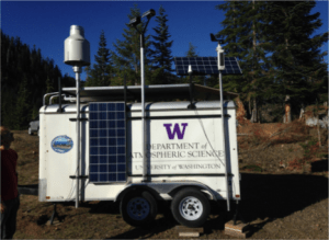
Conrick and Cliff Mass’ research is supported by the OLYMPEX (Olympics Mountain Experiment) field campaign that has a goal of making better measurements of rain and snow coming from the ocean to the coast and also the mountains. The Global Precipitation Measurement (GPM) satellite is used to measure the precipitation over the Pacific Ocean in the weather prediction models. The GPM Microwave Imager (GMI) and Dual-Frequency Precipitation Radar (DPR) are instruments that were used to evaluate the Weather Research and Forecasting (WRF) model. It was found that there were some complications in the model, specifically along the coast.
“In the work I have been doing in the past couple of years, precipitation along the coast has actually been underpredicted for more than a decade. Our modeling systems are struggling to produce rainfall and as a result our precipitation forecasts are actually producing less rain than it is falling in reality .” Conrick said
The models were giving relatively accurate water vapor content, but the cloud water content and rainfall amounts didn’t match up with the current precipitation amounts along the coast of the Pacific Northwest. Conrick is looking forward to bettering the weather models in order to get a more accurate representation of the rainfall amounts along the coast. Since rainfall is underpredicted that means that the hazards that come from extreme rainfall are being underpredicted as well.
“While the work is to fix our weather modeling of this particular type of rain, it is actually more widely applicable in that it can warn people of potential hazards like landslides and flooding.”
Around late January and February of this year, there were records of multiple landslides and flooded areas in Washington State. Due to the countless days of rainfall the vegetation had become supersaturated to the point where landslides were inevitable, and many areas were flooded.
Imagine a Pacific Northwest with better precipitation forecasts. Conrick and Mass might be able to fix that!
By Sara Salimi | The UW Dawgcast


