July 1, 2020
Forecast: July 1st, 2020
By Calen Randall
Hey Huskies!
Happy July 1st, or if you are from north of the border, Happy Canada Day!
Persistent onshore flow has summoned cloud cover, drizzle, and scattered showers to the Puget Sound. Today’s high temperatures should top out in the mid 60s. Winds around 10 mph throughout the day and gusts above 20 mph are expected this evening. Chance of seeing sunsets is low until skies clear around Friday.

Today’s showery weather continues the trend of wet weather in 2020. The figure below details the cumulative rain recorded at SeaTac Airport in 2020 (purple) compared to climatology, or the average (blue). Based on the distance between the curves on July 1st, you can see that rainfall at SeaTac Airport is four inches above average!
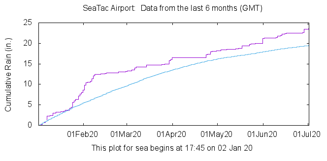
As we head into July, the driest month of the year on average, the National Wildfire Coordination Group has most of Washington listed as “little to no” fire risk, thanks in part to our rainy 2020. Fire potential ratings will change, especially as drier weather takes hold in the coming weeks. Hopefully the above-average rainfall will keep the risk for major wildfires low throughout the summer.
Reach forecaster Calen Randall at theuwdawgcast@uw.edu. Twitter: @Wx19Calen
| MORNING RADAR | TODAY’S FORECAST |
 |
|
