September 17, 2020
Forecast: September 17th, 2020
By Rachael Fewkes
Hey Huskies!
We are waking up to yet another morning of smoke and mugginess, but to the relief of many Puget Sound residents, our days of being engulfed in wildfire stench will soon be over. Air quality has improved slightly into the “unhealthy” category as opposed to the “very unhealthy” or “hazardous” categories we have seen recently, but conditions are still far from perfect. Today will be the last day we’ll have to deal with this yucky brownish-gray haze limiting visibility and just being a nuisance all around throughout western WA.
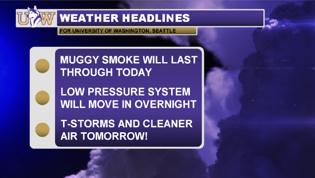
Our saving grace—a low pressure system sitting right off the coast—will be moving in overnight and into tomorrow. This system will bring thunderstorms early Friday morning followed by wind and steady rainfall for the remainder of the day. The slight increase in wind speed, while not overly powerful, will result in some much-needed mixing in the atmosphere and will help to lift the smoke up and out of our region.

Current AQI readings from ecology.wa.gov.
By Friday afternoon, you can expect to be breathing in significantly cleaner air than we’ve seen over the past week. Say your goodbyes to the current air quality readings (see above) because chances are, they won’t be this bad again for at least another year…as long as the lightning on Friday doesn’t spark any more fires. Fingers crossed!
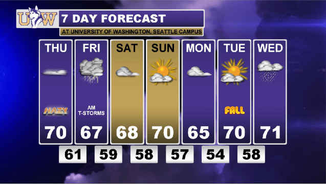
All of this atmospheric cleansing stuff will happen just in time for us to enjoy our last weekend of summer! Temperatures will be cool and comfortable, ranging from the upper 60s to low 70s, and we’ll see overcast skies on Saturday which will partially clear by Sunday.
Reach forecaster Rachael Fewkes at theuwdawgcast@uw.edu. Twitter: @rachaelfewkes.
| CURRENT AIR QUALITY | 7-DAY FORECAST |
|
|
