October 23, 2020
Forecast: October 23rd, 2020
By Chris Thomas
Hey, Huskies!
Most of us are waking up to a cloudy, cool, and rainy Friday morning.
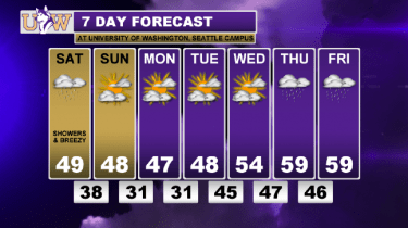
Rain is expected to continue throughout the morning and into the afternoon. However, rain looks to be fairly light and there will likely be some rain shadowing over portions of the Puget Sound, keeping the day from being a total washout for most. Expect temperatures to stay on the cool side and to rise only into the upper 40s – maybe the low 50s.

A cool and showery autumn day is pretty typical weather for us here in the Northwest though. The big story is going to be a push of colder air moving into the region for the weekend. In fact, this weekend will bring us the coldest temperatures we’ve seen so far this season. A freeze watch is in effect for the area from Saturday night through Sunday morning for possible frost and freeze conditions outside. If you have any vegetables still ripening in outside in your garden, now is the time to harvest them. These temperatures will be below average for this time of year, and we may even come close to breaking some records.

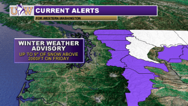
Even with this influx of cooler air, we’ll be too warm for any snow here in Seattle. Our friends in Eastern Washington are likely to to see some of the white stuff though, and the mountain passes should get a good dose of snow too. Definitely keep this in mind if you are planning to travel across the Cascades.

This is a good reminder that winter is coming – time to unpack those scarves and hoodies! There’s good news for all the sun-lovers out there though. Once the rain clears out of the areas tonight, weather in the area looks to be mostly dry and sunny for next several days.

Have a great weekend!
Reach forecaster Chris Thomas at theuwdawgcast@uw.edu.
| WINTER WEATHER ALERTS | 7 DAY FORECAST |
 |
 |
