As an archeology student at the University of Washington, I’ve learned a lot about how archeological research is usually done. Some old cities in the Middle East will be excavated so far down that you need a ladder to reach the bottom and the excavation will cover a lot of surface as well. Cave sites can be similar, where sections with good surface deposits will be dug, field season after field season adding to the excavated area. The artefacts and belongings are usually removed and placed in a climate-controlled collections room far away from the original site and the land is irrevocably disturbed.
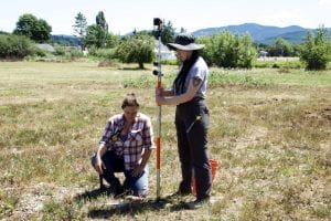
Students using the total station. Image credit to Markee.
Needless to say, I’ve learned that that’s not the Grand Ronde way of doing archeology. We’ve been in the field for a few weeks now and we’ve talked a lot about minimising our impact on the land. We’ve learned about working with developers to work around belongings so that they aren’t damaged or need to be removed, as well as returning soil and items to the ground. Part of why Grand Ronde is able to do this kind of low-impact archaeology is because of the tools invested in, like ground-penetrating radar, which helps you understand what’s underneath the soil. Ground-penetrating radar (GPR) uses radio waves to “see” what’s in the ground, like some boats use sonar to map the ocean floor. Radio waves bounce back to the receiver when they hit something, allowing us to see potential walls, walkways, and objects underneath the soil. We also use pedestrian survey (walking along the ground), Total Station, and GPS mapping to understand what’s on the surface. We map belongings and features, like trees and mounds, with GPS and our GPR units with the Total Station. These maps can then be combined with historical photos to help us identify the areas where we’re most likely to find what we’re looking for.