February 21, 2023
Forecast: February 21st, 2023
Last updated 12:00 PM, Tuesday, February 21st, 2023
By Haley Furutani
Happy Tuesday, Huskies! I hope you all had a restful three-day weekend and are ready to tackle the short week ahead. You may have noticed the strong winds blowing through our area last night, and while the strong gusts have mostly subsided, a frontal system moving out of our region will cause the breeze to persist through Wednesday. Additionally, this system will give us possible wet conditions and plenty of mountain snow.
This afternoon should be mostly cloudy with possible sunbreaks while this evening we may see some precipitation. The high temperature should reach a mild 44 degrees before dropping down to a chilly 32 degrees tonight. This will kick off the next few days of cool temperatures with highs only reaching the 30’s. For those of you keeping an eye on sunrise/sunset times like I am, today the sun rose at 7:04 am and will set at 5:41 pm. I’m loving this gradual increase in daylight and I’m sure many of you can say the same!
 Speaking of the next few days, tomorrow will be a bit chillier than today, dropping down to a high of around 36 degrees. The wind chill should be near 25 degrees and will likely make it feel much cooler, so be sure to bundle up on your way out the door tomorrow.
The low temperatures and lingering moisture in the air gives us a slight chance of snow throughout the week. If enough moisture persists, there is potential for very light snowfall this week.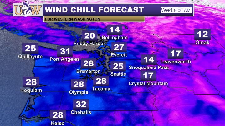
Although Thursday and Friday are looking just as chilly as Wednesday, you’re in luck if you love a sunny winter day. We will likely see some sunshine on Thursday and Friday, just what we need to get through the end of the week.

We will warm up again going into the weekend with temperatures back up in the 40’s. Good luck with the rest of Week 8, Huskies!
Reach forecaster Haley Furutani at theuwdawgcast@uw.edu or on Twitter @TheUWDawgcast and Instagram @UWDawgcast
Recent Comments