October 8, 2020
Forecast: October 8th, 2020
By Rachael Fewkes
Hey Huskies!
Hopefully you caught a couple glimpses of the blue sky yesterday evening after the fog finally cleared, because chances are that is the last significant amount of blue sky we’ll be seeing for a while. Today marks the beginning of a lengthy stretch of dark, stormy conditions and cool temperatures which arrives almost every year in western Washington right around early October. Monday was likely our last day of temperatures exceeding 70 degrees until things start heating up again next spring. Yesterday the thick fog which persisted late into the afternoon around the Seattle area inhibited our temperatures from making it past the low 60s.
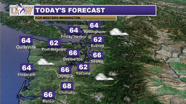
As far as today goes, you can expect more fog along with some clouds moving in, making for mostly gray skies all day long. A few sunbreaks are possible. Highs will reach the low to mid 60s.

Starting Friday, we’ll have a stronger storm make its way into the region, resulting in greater cloud cover and rain lasting through the weekend. Saturday and Sunday will be the most eventful with the potential for scattered thunderstorms accompanied by gusty winds!
Reach forecaster Rachael Fewkes at theuwdawgcast@uw.edu. Twitter: @rachaelfewkes.
| CURRENT SATELLITE | 7-DAY FORECAST |
 |
|
