October 8, 2019
Geology Blog 4: Different Geomorphology and Climate
When we got off the plane in Nanjing, the oncoming was the hot and humid weather. We missed the coolness of Seattle very much. In the past few days, we had experienced a lot of geological phenomena in Seattle and learned a lot of knowledge and ideas. And now, after returning to Nanjing across the Pacific from Seattle, we are more aware of the differences in climate, geology coast and so on.
Different Geomorphology and Climate
Topographically, the landform of Nanjing and Seattle are both hilly. Nanjing is located in the Yangtze River Delta and belongs to the NingZhenYang Hilly Region. The terrain is mainly low mountains and hills. The highest mountain in Nanjing is Zijin Mountain, with its main peak at 448.9 m above sea level. Seattle is also built on hilly terrain. Rivers, forests, lakes and fields are widely distributed in the city. However, if compared with Seattle, the terrain of Nanjing is relatively much flatter. When driving in the city, you will not have a strong feeling of bumpy ups and downs, whether in the downtown or suburbs. Actually, the topography of Seattle is more similar to Chongqing, which is known as the “mountain city” in China.
In terms of climate, there is a big difference between the two cities, although both of them are located on the coast of the Pacific Ocean. Nanjing is significantly affected by monsoon, which belongs to subtropical monsoon climate. There is plenty of rain in Nanjing especially in Summer, and the four seasons are also well-marked different. The annual temperature range is relatively high, reaching 40℃. However, Ocean plays a more important role in the climate of Seattle. It has a temperate marine climate, mild and humid throughout the year, with a relatively low annual temperature range. Seattle is known as “Rain City”, because it is located on the leeward slope of the Olympic Mountains and it is only drizzling for most of the time. In China, Nanjing was once one of the four famous “stove city”, although in recent years, due to the changes in atmospheric circulation and continuous afforestation of the government, the summer temperature in Nanjing has been reduced compared with other cities.
Different Coasts
We went to a lot of the coast of Washington State, including Ruby Beach, Realto Beach, Neah Bay, Strait of Juan de Fuca and Puget Sound. We were amazed by their spectacular views which we have rarely seen in China. The biggest discovery is that there are many coastal bluffs and sea cliffs in the coast of Washington State while broad muddy coasts in China. In general, muddy coasts are easily eroded to form a straight coastline while the bedrock coasts are not easily eroded and forms a tortuous coastline just like Puget Sound. This makes us wonder whether the two different types of coasts on the east and west coasts of the Pacific Ocean respond in the same way to sea level rise in the face of global warming.
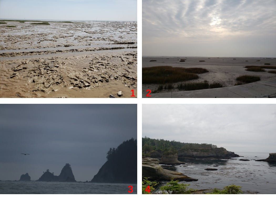
1 Photographed in the Yellow River Delta1,2 Typical Chinese muddy tidal flat
2 Photographed in the Yangtze River Delta
3 Realto Beach
4 Neah Bay
(1, 2, 4 photo by Yang Bao; 3 photo by Qifeng Wan)
Taking the Yangtze River Delta where Nanjing is located as an example, it is the main pioneer of economic development in China converge a large population and society communities. As the estuary of the China’s longest river, the Yangtze River, the natural property of the Yangtze River Delta coast is more complex, especially impacted by rising sea levels. According to the 2017China Sea Level Bulletin, the sea level rise rate of China’s coastal areas from 1980 to 2017 was 3.3 mm/year, higher than the global average over the same period. The rate of the Yangtze River Delta is exceeding the global or national average. The threat and damage caused by sea level rise in the Yangtze River Delta embody in coast erosion, increasing storm surge, seawater intrusion, intensifying flood disasters. As the coastal plain is widely distributed in China, the coastal economically developed and densely populated, highly centralized social wealth, most of the coastal areas should be taken protective measures. The key measures for protective measures are to build or enhance the reinforced moisture-proof seawall.
Similarly, Washington’s coastal areas and marine waters are not only important economic engines for the state but also provide an irreplaceable important position and image in the traditions and culture of tribal communities. The state’s coastline also provides valuable ecosystem services that support human and natural communities alike as the ecosystems of snow-capped mountains, stately evergreens, scenic rivers, and tugged coasts. The region is also blessed with an amazing diversity of coastal habitats, from rocky bluffs and sandy beaches along the Pacific Coast to the tidal flats, marshes, mixed sediment beaches, and eelgrass beds of Puget Sound. Unfortunately, climate change and human activities have been damaging or destroying the Washington coast. According to the Washington State Department of Natural Resources (WADNR), 70 percent of tidally-influenced wetlands in Puget Sound have been damaged or destroyed by urbanization, port development, industrial and agricultural activities, dredging and filling (WADNR, 1998). What’s more, more and more institutions and research focus on the projection of sea level rise and what’re the impacts will sea level rising trigger for Washington State. (projected sea level rise for Washington State; Mote, Philip, et al. (2008) Sea level rise in the coastal waters of Washington State.; Glick, P., Clough, J., & Nunley, B. (2007). Sea-level rise and coastal habitats in the Pacific Northwest. ) Unlike China’s response, Washington State will need longer-term planning and decision-making to decide whether to withdraw from endangered shores and cliffs, or to invest in structural protection or adaptation projects(Daniel D. Huppert , Amber Moore, Karen Dyson. Impacts of climate change on the coasts of Washington State.)
Different volcanoes
Both Seattle and Nanjing have a history of volcanic eruptions. The volcanoes in the two places have their own characteristics. We’ll talk about the genesis,scale and lithology.
The formation of volcanoes in Seattle is related to plate subduction, the Cascadia subduction zone on the western coast of Washington State. The Farallon Plate was formed after the Jurassic cleavage of the ancient land Pangaia. After a long plate movement, the Farallon Plate body has been subducted below the North American plate, and the remaining part on the north side can be divided into Juan de Fuca Plate, Explorer Plate and Gorda Plate.
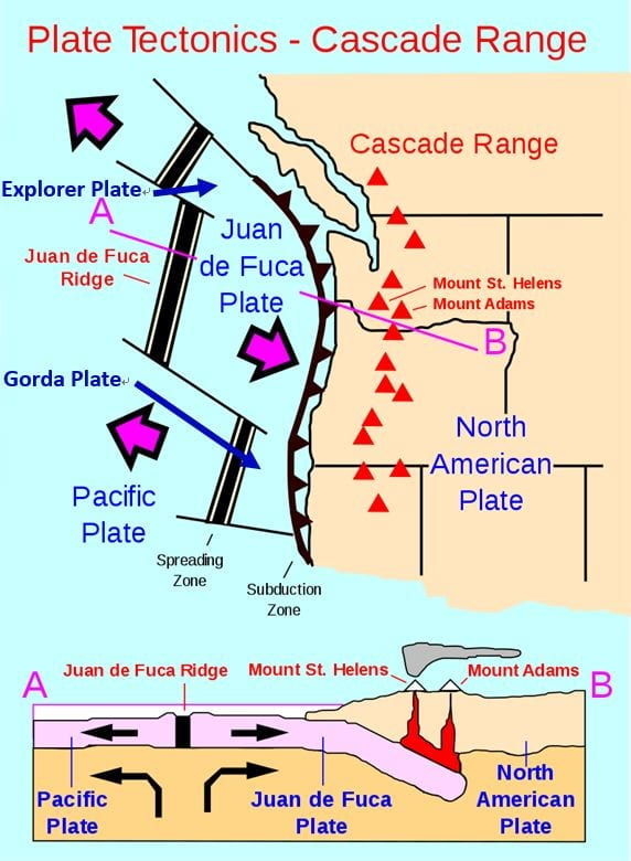
Geology of the Cascade Range-related plate tectonics.
(Photo from https://en.wikipedia.org/wiki/Cascade_Range)
The volcanoes in Nanjing belong to the continental margin of the Pacific Rim volcanic belt and are formed by the compression of the Pacific plate and the Eurasian plate.
Most of the volcanoes in Seattle are active volcanoes, such as Mount Rainier, which was recently erupted in 1894. The volcanic eruption in Seattle is large, and Mount Rainier is considered one of the most dangerous volcanoes in the world. The volcanoes in Nanjing are basically extinct volcanoes, such as Liuhe Mesa and Jiangning Mesa. The elevation of these volcanoes is only about 100m, and the exposed area of volcanic cones is 2~3 square kilometers.
The volcanic bedrock in Seattle is granite and the volcanic body is andesite. The Pliocene is an important period of basaltic volcanic activity in Nanjing, so the volcanic lithology of Nanjing is dominated by alkaline basalt.
Different Geology
Washington State, including Seattle, is the smallest state in the western United States, but its rich and varied geological phenomena can be seen everywhere. The main types of rocks in the state reflect an active geological history of more than one billion years. According to geology, Washington is divided into six distinct regions: North Cascade, Coast Range, Puget Lowland, South Cascades, Okanogan Highlands, and Columbia Basin.

Roadside Geology of Washington
(Photo from https://geologictimepics.com/)
Our area of study this time mainly involved the Coast Range, Puget Lowland and South Cascades. The Coast Range includes the Olympic Mountains in the north and the Willapa Hills in the south, which are mainly composed of young marine basalts and sedimentary rocks. Puget Lowland was largely covered by glaciers during the Pleistocene period, and the most recent ice age (narrow) “Vashon Stade” has shaped the terrain to a great extent. The low valleys that have been left behind by glacial erosion have now mostly become rivers or lakes, such as Lake Washington. One of our destinations, Seattle, the capital of Washington State, is also located in the area. The main geological origin of the South Cascades region is volcanic activity and is still active, so the main rocks are volcanic rocks. The Mount Rainier and Mount St. Helens, which we focused on during our visit, are located in this area.
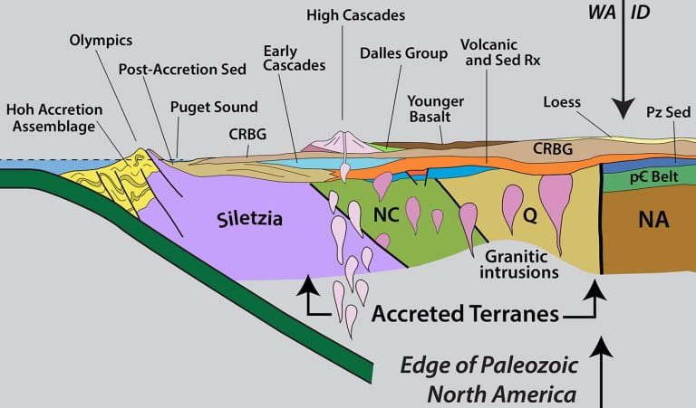
Geological section of Washington
(Photo from https://geologictimepics.com/)
From this geological section concept map in Washington State, we can see the overall tectonic setting of the Pacific plate subduction to the North American plate.
For our hometown of Jiangsu Province, on the eastern coast of China, it experienced several tectonic activities such as Caledonian, Haixi, Indosinian, Yanshan and Himalayan, and formed a relatively complete geological history in the evolution of the Earth. Stratum. Magma activity is frequent and diverse, with many mineral resources. Unique geological relics are formed, so the School of Geology of our school organizes students to study the geological conditions of Jiangsu Province every year. Although geologically diverse, it is not as active as the Washington area. There are several active volcanoes in Washington State, which are located on the Pacific Rim volcanic belt and often have earthquakes. In Jiangsu, we can feel that there are not many earthquakes and the geological structure is relatively stable.
Although this expedition has ended, we will never forget Monika’s erudition, Megan’s enthusiasm and Jonathan’s smile and appreciate their help and guidance during these ten days. This joint international scientific research activity has brought us some conceptual impacts that will affect our future study and research.