August 25, 2023
2023 Ecology Group Blog 3
Blog 3 of Ecology Group
Our blog is written to cover after day6. We moved from Nature Bridge to UW campus. Along the way, we saw different ecosystems, We have experienced changes in ecosystems, from forest ecosystems to Marine ecosystems till cities, and we learned about the interactions between human activities and ecosystems. In addition, we learned about the relevant applications of Lidar technology. So we will talk about the following 4 aspects.
1、Ecosystem in Dungeness National Wildlife Refuge
We went to Dungeness National Wildlife Refuge on August 23rd. It’s very beautiful there and the ecosystem is even more interesting.
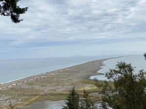
Photo1:Dungeness National Wildlife Refuge
By Norihiro Suzuki
At Dungeness National Wildlife Refuge, the world’s longest natural sand spit softens the ocean’s turbulent waves, creating shallow, tranquil bays rich in marine life. These waters and tidal flats are places to rest and protect wildlife from the wind and surf. Eelgrass feed large schools of blunt and create nurseries for juvenile salmon and steelhead. The tidal flats are crowded with migrating shorebirds in spring and autumn. During the winter months, the calm waters attract a wide variety of waterfowl.
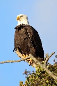
Image of Bald eagle
Photo2: From https://www.flickr.com/photos/lekasfamily/32152246060/sizes/l/
The bluffs above the sandbars contain coniferous forests, home to black-tailed deer, songbirds and raptors. Tree snags are convenient observation sites for bald eagles. Cliffs are inhabited by Pigeon Guillemot in the sand and glaucous-winged gulls that roost on outcrops.
A row of driftwood above the high water mark stabilizes the spit and provides a refuge for sandpipers and a perch for peregrine falcons to search for prey. On the seaward side of the sandbar, bulbuls, thunderings and black-bellied plovers scour the sands for invertebrates. Spotted seals rest and nurse their pups in the nature reserve.
Nutrient-rich sediments accumulate on the leeward side of Dungeness and Graveyard Spits. The mud seems lifeless, but millions of worms, clams and crustaceans burrow beneath its surface. When the mud is exposed at low tide, shorebirds such as sandpipers, dunlin and whimbrels seek out this hidden bounty.
Protected from raging waves and fertile with nutrients falling from above, Dungeness Bay is teeming with fish and invertebrates. The bay’s eelgrass beds provide food and nursery grounds for juvenile Dungeness crab, flounder, salmon, steelhead and cutthroat trout. In winter, flocks of waterfowl, loons and grebes find food and shelter here.
Global warming is caused by excessive amounts of greenhouse gases accumulating in the atmosphere, trapping heat.Rising temperatures due to global warming will melt the polar ice sheets, add water to the oceans, and cause sea level rise.Due to its low-lying location, the Dungeness tidal flats are threatened by rising sea levels.The Dungeness ecosystem may disappear due to global warming.
Through the workshop, we are realized that we must protect nature.
(This section was written by nori and Shosuke)
2、Lidar technology and its usage
After watching the video presented by Professor Monika, I thought LiDar was very convenient. In order to learn more, we reached out to Professor Akira after the documentary .We discussed with Professor Akria from Chiba University in Japan about the many applications of Lidar in forestry, which we were very interested in and learned a lot.
What is Lidar:
Light Detection and Ranging (LiDAR) is a new active remote sensing technology, which can obtain high-resolution three-dimensional topography, vegetation structure parameters, leaf area index and other parameters of forest ecosystems on multiple spatio-temporal scales. Its working principle is to analyze the reflected energy of the surface of the target object, the amplitude, frequency and phase of the reflected spectrum by measuring the propagation distance between the sensor and the target object, so as to realize the accurate positioning, identification and detection of some characteristics of the target object.
Generally, according to the different bearing platforms, it can be divided into spaceborne, airborne and ground lidar.
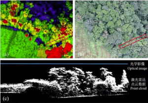
Figure 1 Comparison of LiDAR point cloud data (a) and traditional optical image data (b), (c) is point cloud profile data
From:https://zhuanlan.zhihu.com/p/35570622
Lidar in forestry:
Terrain has always been regarded as an important environmental influence factor in ecological research. On the one hand, it is an important reference factor for dividing site conditions; on the other hand, terrain factors promote the differentiation of community habitats through the redistribution of light, water and soil conditions, and thus indirectly affect the biological characteristics of plant communities such as species diversity and stock amount.
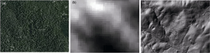
FIG. 2 Comparison of the effect of LiDAR generated DEM with other data DEM products. (a) Aerial image (b) Aerial image DEM, 30 m resolution; (c) DEM generated by LiDAR, resolution 1 m
From:https://zhuanlan.zhihu.com/p/35570622
Compared with the traditional quadrat survey, the most prominent feature of LiDAR technique is both detail and large scale. It can be said that LiDAR generates a “model” of the real world, which is a real three-dimensional community that can be measured when applied to forestry and ecology.
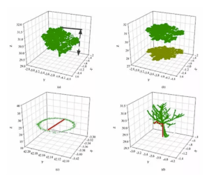
FIG. 3 Schematic diagram of extraction of 3D habitat quantification parameters (a) tree height; (b) Crown width; (c) diameter at breast height; (d) Height under the branches
From:The images are the results of Guo Qinghua’s research team, Institute of Remote Sensing and Geographic Information System, Peking University
At present, there are two main methods for calculating leaf area index: direct measurement method and indirect measurement method. The direct measurement method is time-consuming and labor-consuming, and has great destructiveness, so it cannot be widely used. Indirect measurement methods mainly include optical instrument method and passive remote sensing method, the former results are obviously underestimated, the latter is prone to saturation problems.
However, the introduction of LiDAR technology can significantly improve this problem. The advantage of LIDAR data is that it can obtain LAI of any scale and at any position, avoiding the error caused by the fisheye lens method due to the selection of photographic position. More importantly, it can capture the continuous change of LAI in the vertical direction. At present, there are more and more researches on LAI estimation using LiDAR. For example, Dr. Li Yumei from the research group of Guo Qinghua, proposed a new extraction algorithm based on porosity and aggregation coefficient, which takes porosity theory as an important theoretical basis to achieve accurate LAI measurement
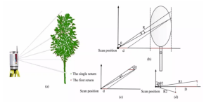
FIG. 4 Schematic diagram of single-station scanning
From:The images are the results of Guo Qinghua’s research team, Institute of Remote Sensing and Geographic Information System, Peking University
The main applications of LiDAR in forest remote sensing are summarized as follows:
- Count and locate trees. LiDAR can directly detect and locate each individual tree, improving the accuracy of counting the number of trees.
- Estimate the tree height. LiDAR can directly measure the distance between the top of the tree canopy and the ground to obtain accurate tree height.
- Estimating canopy structure parameters. Such as canopy vertical stratification, canopy density, canopy coverage and so on.
- Estimated standing volume. LiDAR can quickly obtain the trunk volume of standing trees in a sample area and infer the volume of the entire stand.
- Estimate the biomass. LiDAR can be used to quickly and accurately estimate biomass indicators such as forest carbon storage.
- Model forest structure. Detailed 3D forest structure models can be built using LiDAR data.
In summary, LiDAR point cloud data provides rich three-dimensional structure information, which greatly improves the efficiency and accuracy of forest parameter extraction.
In my opinion, with this technology, we can understand the general forest status of the research area before field work, and it is more convenient to determine sampling plans and methods, which saves a lot of time for work.
(This part was written by Zijun Wu)
3、Plant identification
On the hiking trail, we saw a variety of plants, distinguishing these plants is the basis of field work, and we discussed this aspect as follows
Comparing plant characteristics with the illustrated book is one way to identify plants. Many people compare only flower, but it’s not enough. We can only see flowers for a limited season. In other words, plant identification needs overall evaluation of leaf size and shape, fruit, seed, branch growth. Especially, identifying conifer such as Western red cedar, douglas fir, red fir needs comparisons of leaf and cone. However, many conifers are taller, so it can be difficult to see the leaves at hand. I explain conifer identification using some species we saw in this workshop.First, western red cedar (Thuja plicata) has scaly leaves, and cone is relatively small (Figure1). From this description, we understand that the plant isn’t Pinaceae like pine and hemlock.
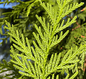
Figure 1 Leaves of western red cedar
From City of Seattle Official Website, https://www.seattle.gov/trees/planting-and-care/trees-for-neighborhoods/past-plantings/western-red-cedar
Next, douglas fir (Psedoutsuga menziesii) has needle-like leaves and distinctive cone (Figure 2). Three-lobed organs emerge from between the piece of cone.
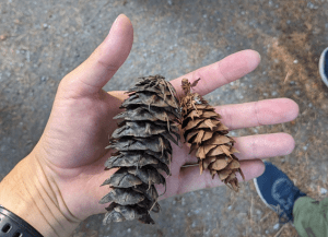
Figure 2 cones of douglas fir
(Photo by Kazutaka Tabata)
One thing to keep in mind is that it should be noted that the fruit of alder is similar to the cone of conifers (Figure3). However, alder is not conifer, so it has broad-leaves.
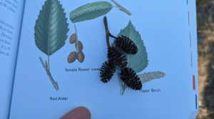
Figure 3 fruits of red alder
(Photo by Kazutaka Tabata)
References
- City of Seattle Official Website, https://www.seattle.gov/trees/planting-and-care/trees-for-neighborhoods/past-plantings/western-red-cedar
(This part is written by Kazutaka Tabata)
4、Connection between agriculture and the environment
On our way to Seattle we saw the ecosystem change from woodland to ocean to city. Students from Chiba University were interested in the relationship between ecosystems and agriculture, and they had the following discussion
Seattle’s agriculture is closely related to its ecosystems The Seattle area’s ecosystems include a variety of natural environments such as forests, lakes, rivers, and oceans. These natural environments provide rich resources for agriculture. For example, they provide water for irrigation and offer favorable climatic conditions and soil quality for growing crops. Agricultural activities also have an impact on ecosystems. For example, the use of chemical fertilizers and pesticides can pollute water and soil(Photo1).
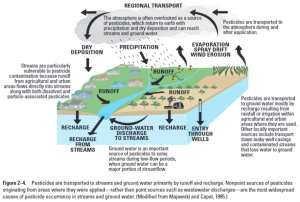
Photo1. Pesticides pollute the environment.
This picture is from:https://www.usgs.gov/media/images/pesticides-are-transported-throughout-environment
By the way, In vlog 2, I discussed salmon conservation. One of the reasons why salmon numbers are declining is the pollution of water bodies. As I mentioned earlier, I believe that agriculture is also related to the pollution of water bodies.
An additional problem that has become an issue in water pollution from agriculture is the problem of microplastics(Photo2). Microplastics are the smallest plastic particles, less than 5 mm in diameter. They do not decompose naturally, are lightweight, and are easily carried away by waves and wind. Because plastics do not decompose, they drift semi-permanently in the ocean, despite being so small that they are invisible to the eye. Fishes sometimes mistake microplastics for food and eat them. In some cases, for example, microplastics that enter the body become lodged in internal organs, while in others, harmful chemicals attached to the microplastics accumulate in the body. If farmers use a lot of chemical fertilizers and plastic for profit, it will have a negative impact on the salmon.

Photo 2. Photo of microplastics
This picture is from: https://education.nationalgeographic.org/resource/microplastics/
In other words, each industry should not only work for their own profit, but should also consider the negative impact on the environment, ecosystems, and other industries. I think Seattle needs to balance agriculture and ecology for sustainability and environmental protection.
(This part is written by Ryo Suzuki)