August 26, 2023
2023 Geology Group Blog 3
Differences in coastal landforms
Have you seen our blogs No.1 and 2? We have explained in these blogs, in an easy-to-understand way, how the topography of the PNW is formed. If you have yet to see it, please check the previous articles. In previous articles, we have introduced volcanic activities and lakes, and this article will focus on the formation of the coast further downstream. Coasts are formed by erosion or deposition, each with its characteristic shape. We will introduce coasts formed by erosion and deposition, respectively.
Cape Flattery is located on the Olympic Peninsula in the United States. In 170 million years B.C., Mt. Olympus experienced a series of volcanic eruptions that condensed magma to form large amounts of basalt and andesite. In 50,000 B.C., Elba Peak in the area underwent an eruption that also formed much basalt and andesite. In 20,000 B.C., the strata on which Cape Flattery is located collided with a nearby ocean floor plate, which created the ridges and canyons of the area and resulted in crustal and volcanic movement. The geologic history of Cape Flattery area has, directly and indirectly, contributed to the formation of the local landforms, and the compact igneous and metamorphic rocks became the foundation of the rockily coastal landforms here. which yielded complex geological structures and a variety of rock types.
The landforms in Cape Flattery are various and typical, including sea caves, sea cliffs, wave-cut platforms, sea stacks, and so on. How are they carved?
During long times of high tides, the waves attack the base of the cliffs. In these periods, joints and fault lines which are relatively weak in the compact rocks here are progressively undercut by wave erosion, resulting in the formation of wave―cut notches. As these notches are enlarged, eventually the overhanging rock collapses because of gravity. As this process is repeated, the cliffs retreat, exposing gently sloping rock surfaces called wave-cut platforms (Figure 1) [1].
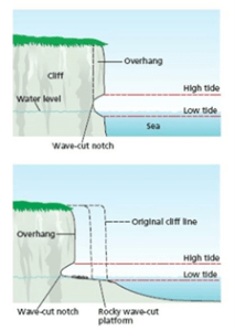
Figure 1 The formation process of a wave-cut platform
(From Desert Landscape Design Software Free Crack, How Do Coastal Landscapes Form, Front Yard Landscaping Retaining Walls And, Landscaping Supply Store 900, https://s3.us-east-1.amazonaws.com/chwlandscapemob/how-do-coastal-landscapes-form.html)
Similar to the formation process of a wave-cut platform, the waves lap against the coastline, eroding weaker parts of the rocks. Over time, the cracks grow bigger, and become sea caves and then arches. Eventually, the accumulated erosion causes arches to collapse, leaving only erosionresistive rocks isolated from the mainland. These pillars are sea stacks (Figure 2,3,4).
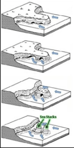
Figure 2 The formation process of sea caves, sea arches, and sea stacks.
(From GEOCATCHING, A Needle in a Sea Stack, https://www.geocaching.com/geocache/GC2R00T)
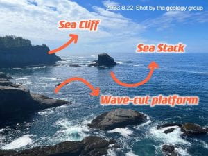
Figure 3 Sea cliff and sea stack at Cape Flattery
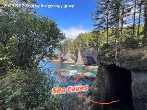
Figure 4 Sea caves at Cape Flattery
Around the Pacific Ocean, on the northwestern margin, Japan is another area with volcanic activities. The Japanese islands, adjacent to convergent-type plate boundaries, have been subject to active crustal movements similar with the area where Cape Flattery is located. Complex geological structures and a variety of rock types as Cape Flattery has which are yielded by volcanism and metamorphism, occupy about 60% of Japanese total coastline (Figure 5, 6) [2].
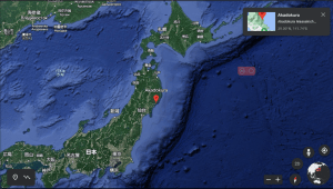
Figure 5 The location of Anatoshi Iso (39°N,141°E)
(From Google Earth)

Figure 6 The rocky coast of Anatoshi Iso (Iwate, Japan)
(From Tripadvisor, https://www.tripadvisor.com/Attraction_Review-g1022870-d11878371-Reviews-Anatoshishiso-Ofunato_Iwate_Prefecture_Tohoku.html)
Besides, there are also rocky coasts in China. Areas such as Shandoong Pilinsula, Hangzhou Bay, and Southern islands are typical of bedrock coast, which are also found upon volcanism and metamorphism.
In conclusion, we can see that, connection in coastal erosion happens worldwide. To read and treat our earth as a whole home, not only from geology perspective, we could better understand and protect the planet of our own.
In geography, spit is a landform made by the deposition of sand by the movement of tides. Spits are narrow and elongated – one end is attached to the mainland and the other is out in open water. A spit develops when waves meet the beach at an oblique angle, moving sediment down the beach and into the open waters where it is deposited in a narrow strip [3].
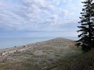
Figure 7 Dungeness spit
Dungeness National Wildlife Refuge protects critical habitat for wildlife.
About 10,000 years ago, melting glaciers left thick deposits of sand and gravel along the coastline here.
Dungeness Spit was created and continues to be changed by the actions of winds and water on these glacial sediments.
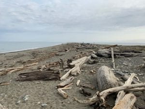
Figure 8 Driftwood and beach plants
The wind blows very strongly at this location. That wind drives the waves. The waves pushed sand and cobbles diagonally up the bey, and then swept it backward. This forms the slit.
Driftwood and beach plants hold the sand in place. This keeps the forces of erosion in check. Today, the spit continues to grow at its top, 13 feet (4.4m) per year.
We compared Amanohashidate, which is one of the most famous sandbars in Japan, with the Dungeness National Wildlife Refuge and Amanohashidate.
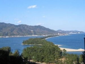
Figure 9 Whole view of Amanohashidate
(From Kyoto prefecture’s HP, Photobook of Amanohashidate, https://www.pref.kyoto.jp/tango/tango-doboku/hashitate_photo.html)
According to Arii(2010) [4], Amanohashidate formed a submerged sandbar on the seafloor about 20,000 years ago due to the collision of two different tidal currents and appeared on the sea floor about 2 to 3,000 years ago due to the lowering of the sea level.
The underwater bar appeared on the sea floor about 20,000 years ago due to the collision of two different tidal streams.The sandbars then grew from north to south due to the transport of sand by the longshore currents, as in the Dungeness national wildlife refuge. However, the growth of sandbars is not only due to currents, but also to the increased supply of sand due to increased land development.
References
[1] Desert Landscape Design Software Free Crack, How Do Coastal Landscapes Form, Front Yard Landscaping Retaining Walls And, Landscaping Supply Store 900, 2021
https://s3.us-east-1.amazonaws.com/chwlandscapemob/how-do-coastal-landscapes-form.html
[2] T.Sunamura, H.Tsujimoto, and H.Aoki, 2014, Chapter 12 The rock coast of Japan, Geological Society, Vol.40, 203-223
[3] AMUSING PLANET, 2013, 7 Most Spectacular Spits on Earth
https://www.amusingplanet.com/2013/07/7-most-spectacular-spits-on-earth.html
[4] H. Arii, 2010, The formation process of Amanohashidate (Amanohashidate no Keisei katei ni tsuite), Kyoto prefecture Research on Buried Cultural Properties (Kyoto maizo bunkazai kenkyu), Vol.6, 411-418 (in Japanese)