Category Archives: Blog – uncategorized

USGS collaboration: Astoria Canyon sediment core processing

As a part of the USGS-UW Cascadia Canyons project, the sediment dynamics group recently traveled down to the USGS Pacific Coastal and Marine Science Center in sunny Santa Cruz for one week of sediment core processing. The cores on the “operating table” this week were 9-meter-long jumbo piston cores collected from the muddy floor of Astoria Canyon between 700 and 1500 m water depth. The complete core processing workflow included CT density scanning, core splitting, photography and subsampling. Once our work was complete, we sealed cores into airtight tubes to be archived in a USGS core repository.

These cores are among the longest sediment records collected from this region of Astoria Canyon, and they have already given us valuable insight into canyon mass transport events (turbidity currents and debris flows) during Holocene sea level highstand. A primary feature of these cores are the turbidite deposits that vary in lithology, thickness, age and frequency from core to core. While the canyon was once thought to rarely experience mass transport during Holocene highstand, this new evidence indicates that several transport events have occurred within the last 300 years.

NSF Cascadia Canyons – Sensor Systems Deployed!

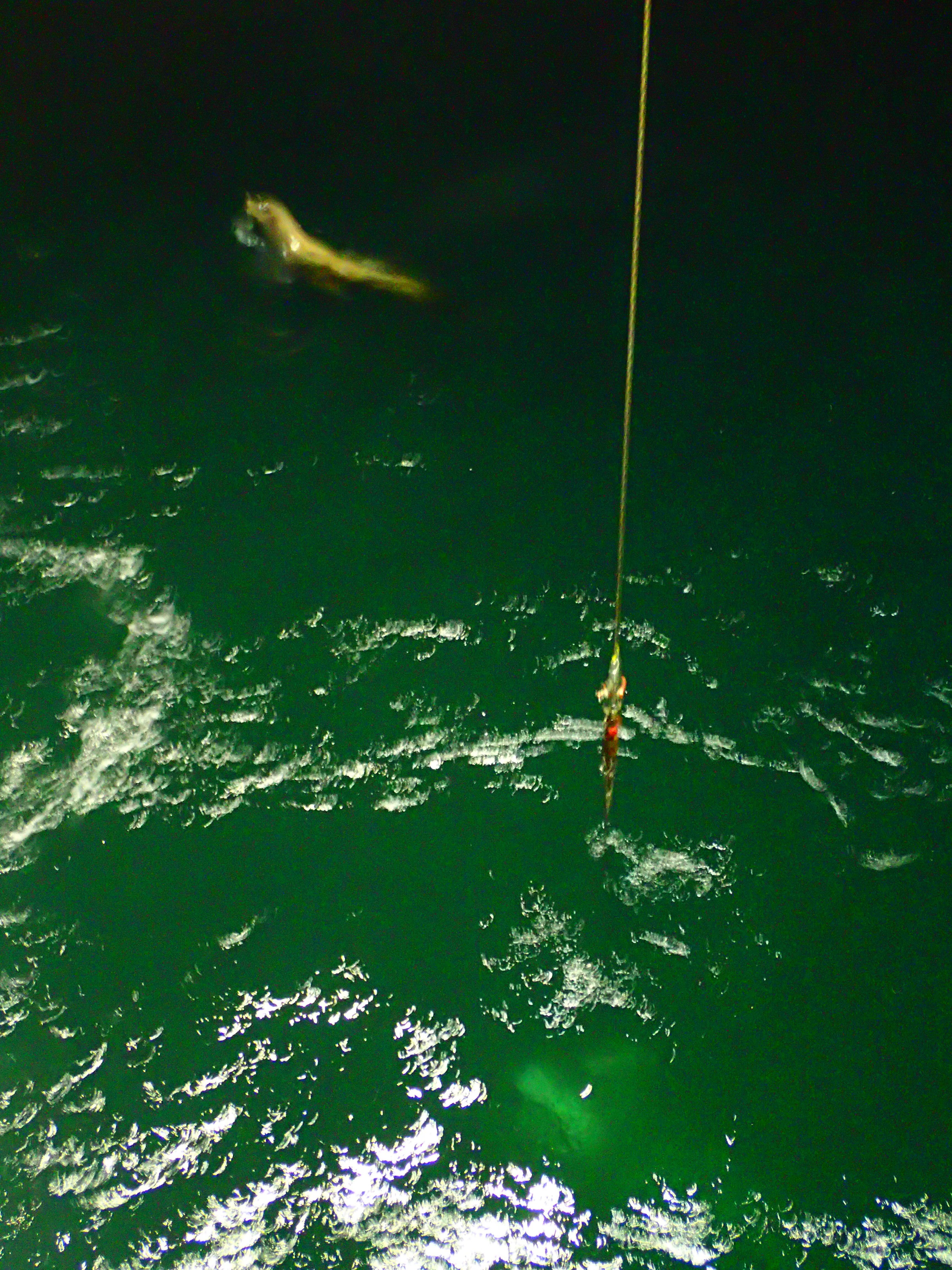
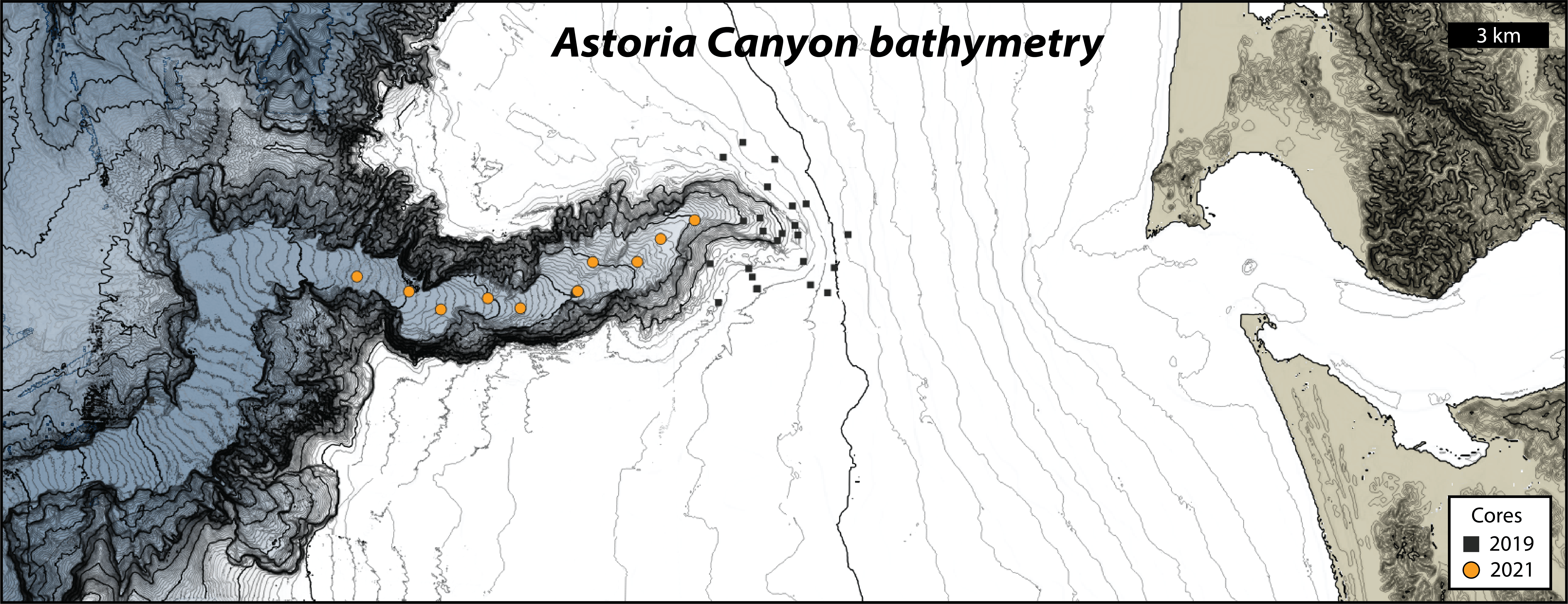
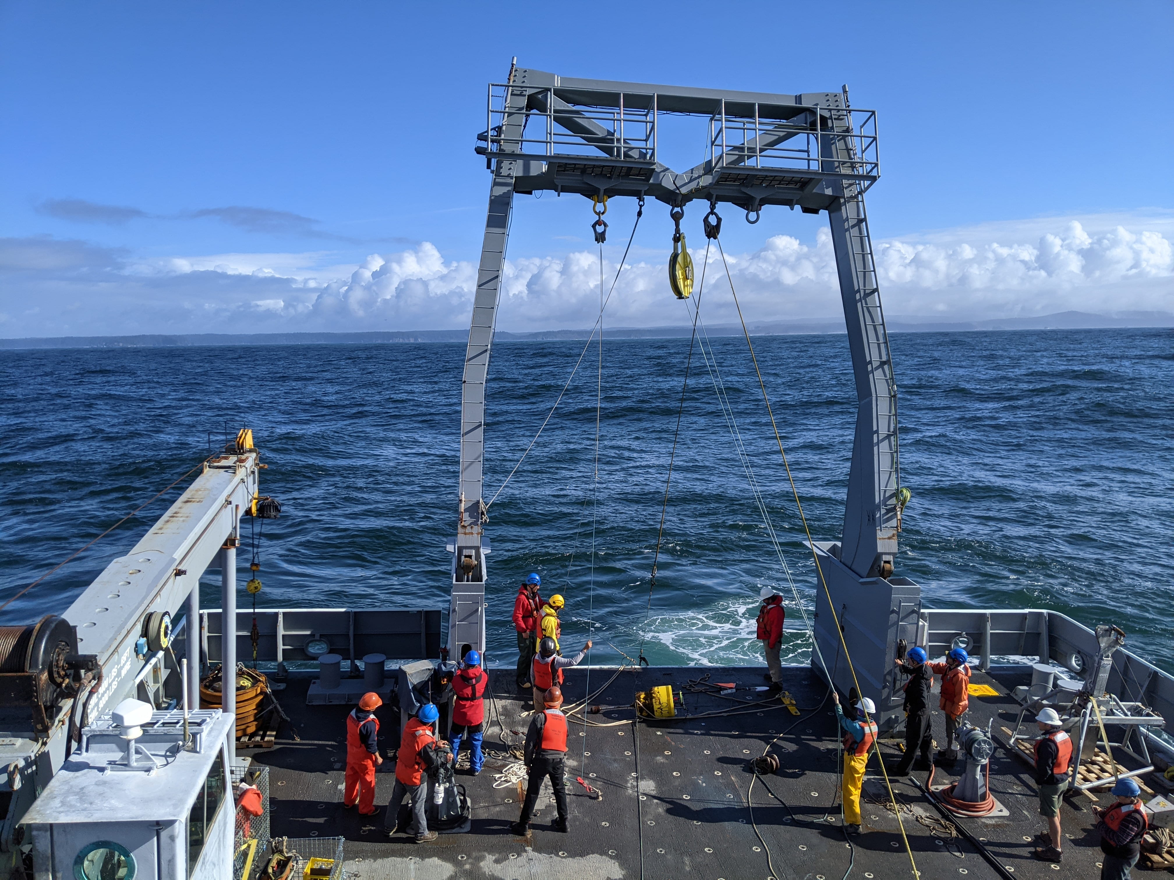
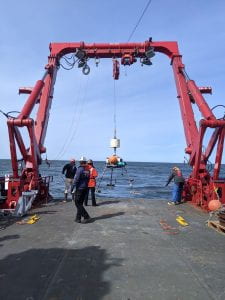
A successful cruise on the R/V Sikuliaq in early April, 2023, has kicked off our year-long experimental program exploring sediment gravity flows on the Cascadia Margin.  We placed moorings and bottom boundary layer tripods in the upper canyon reaches of two systems:  Astoria and Quinault.  These two canyons have very different morphologies and relationships with their modern-day sediment supply, the Columbia River.  With the instrumentation we are hoping to capture a range of sediment gravity flows over the year-long deployment.  Seabed coring of the canyon thalwegs and surrounding continental shelf and slope give us clues as to triggering mechanisms, gravity-flow dynamics and seabed deposits resulting from these flows.  UW Sediment Dynamics group participants: Andrea Ogston, Chief Scientist; Evan Lahr, Tripod Builder and Coring Op Lead; and Sarah Vollero, Coring Ops.

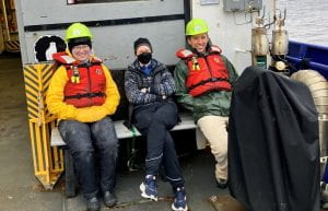
The project is being undertaken through a collaboration with the USGS Pacific Coastal and Marine Science Center (led by Dr. Jenna Hill and Kurt Rosenberger).  In addition, we had the pleasure of being joined on the cruise by a UW Sediment Dynamics alumni, Dr. Emily Eidam, Oregon State University, and graduate students Adrian Heath (OSU) and Jonathan Moore (V Tech).

At long last, a return to sea!

After what seemed to be an eternity (ok, about a year), the sediment dynamics group was reunited with the open ocean for data collection in the axis of Astoria Canyon. The cruise departed from Newport, Oregon on the RV Thomas G. Thompson, and arrived at the Marine Sciences Building dock in Seattle a week later. The research goals of the cruise were to 1) collect a suite of sediment cores from Astoria canyon, and 2) service many of the Applied Physics Laboratory‘s instrument moorings such as ChaBa.  ~15 undergraduate students were also aboard the ship, gaining firsthand experience collecting data for these research projects. Both research objectives were successful, although ocean conditions tested our crew with high winds and 20-foot swell.

The sediment dynamics group is especially excited about this recent haul of mud from Astoria Canyon. Our research in Astoria Canyon began in 2019, with a series of cores collected from the uppermost canyon head (see map below), and an instrumented tripod deployment measuring water column processes. In this early study, we observed the potential for down-canyon sediment flushing by sediment-gravity flows, and rapid sediment loading in the canyon head, but these findings raised additional questions about the fate of sediments resuspended in the canyon head. Does the shelf-incised canyon axis act as a permanent sink for small, off-shelf gravity flows? Where is the canyon-axis depocenter? Is it possible to trigger a through-canyon sediment gravity flow with shallow oceanic sediment resuspension? The cores collected on this recent cruise march deeper into the canyon axis, aiming to address these questions. Stay tuned for our analysis of these exciting new cores!


Sunset in Newport prior to departure.

A curious seal checks out our coring gear at the head of Astoria Canyon.

Hannah recovering the corer like a boss.

Sediment cores collected from Astoria Canyon in 2021 and 2019.

Recovering a subsurface mooring in calm seas.

The tight squeeze through the Ballard locks on our return to the ocean dock.

CERMIT the tripod has landed!

The sediment dynamics group has been thinking deep thoughts lately–170 meters deep, to be exact. This winter, the lab outfitted a new benthic tripod frame with instruments to quantify sediment transport in Astoria Canyon, the submarine counterpart to the Columbia River. Fast forward to this May, the lab hitched a ride on the RV Oceanus for a week and set our tripod in the head of the Canyon to record a summer of canyon events and processes. While the Oceanus pitched and rolled a few extra degrees with its heavy lift crane atop the second story, the ship and its crew were wonderful help in nestling our tripod safely into the narrow canyon head.

Both amphibious and gangly, we believe the acronym CERMIT will stick (Canyon Edge ReMote In-situ Tripod), though fans should feel free to write in with their suggestions. CERMIT is outfitted with a long list of additional acronyms: multiple ADCPs, OBSs, CTDs, an ABS, a LISST, and more. These instruments will tell us precisely where and how fast the water is moving, and the concentration of sediment along for the ride. This summer, with a bit of luck, we will catch a few of the sediment-gravity flows that travel through Astoria Canyon, and determine what caused them: earthquakes, dredging for fish, or the (less-and-less) mighty Columbia may be the culprits. This information, in turn, helps our lab and other geologists interpret sedimentary deposits nearby and across the globe.

Stay tuned for its recovery and results this September!

UW vans arrive at the Oceanus carrying the tripod (deconstructed for travel). After this photo was taken, we got to work assembling it in the sunshine!

After construction on the dock, a crane brings the tripod aboard the Oceanus.

On the morning of deployment, the tripod is moved under the A-frame for lowering.

The tripod sneaks overboard, with everyone thankful for small swell.

Goodbye for now, CERMIT!

Show and Tell

People in earth science spend a lot of time thinking about the places we study. We work to understand how this mysterious place functions: we read papers, crunch equations, and scroll into satellite imagery. And then, with a van full of gear and a new set of questions, we drive until we find ourselves standing in that very place. It can be a powerful moment, and no one knows the feeling better than seasoned scientists. Chuck and Dave (both seasoned) are teaching a course this term, Rivers and Beaches, focused on giving students that duality. The class begins in a lecture hall, but students are soon out on field trips to the mountains, rivers, and beaches of the beautiful pacific northwest.

Students in this year’s class have now stayed up into the small hours of the night studying geology and oceanography for their midterm exam (today!), but they have also seen and touched these places. Last month, we traveled the length of the Nisqually river from its glacial headwaters to its salty estuary, tracking its transformation from rocky braided channels to gentle downstream meanders. Last week, the students were on a cruise of Puget Sound, testing classroom concepts by lowering CTD rosettes into the water and winching kasten cores out of the Sound’s muddy bed. Textbooks cannot offer the intuition and appreciation for these places and phenomena; building stronger students requires we show them, not simply tell.

It’s too early to tell who in the class will major in a geoscience, but we have one more trip to convince them, amongst the foggy mountains and sandy spits of the Olympic peninsula.

Dave and Chuck on the Nisqually river.

Dave discusses the consequences of a dam along the Nisqually river.

Hustle and bustle as students touch a Shipek sediment sample taken by the R/V Carson.

Observing texture on a 15×180 cm kasten core taken from Puget Sound (core bottom in the foreground).

Hello, Goodbye!

This September is a bittersweet time for the Sed Lab. Nils’ sabbatical is coming to an end. He and his family will return to Brazil at the end of the month. At the same time, Andrea and Hannah will head to Friday Harbor Labs to teach the biannual Marine Sedimentary Processes Research Apprenticeship for the fall. But it’s not all goodbyes, we are also welcoming Evan, a new graduate student! Evan is joining us after finishing his BA at Carleton College (check out his bio on the freshly updated People Page). He will be diving straight into lab work with Aaron, processing samples from the Ayeyarwady.

Stay tuned this fall to hear more from Nils as he continues to publish papers, from Chuck and Evan as they teach Rivers and Beaches, and from Andrea and Hannah in Friday Harbor as they guide students through research projects investigating the Elwha River.

The Sed Lab gathered on Nils’ porch this week for lab meeting.


Family Heirlooms in the Sediment Dynamics Lab

When you join academia, you join a family. Just like all other families, we have family heirlooms that get tucked away and rediscovered by younger generations. Stories are passed down, old photos are dug up, and memories are shared. Just a couple weeks ago, our lab group reorganized our shipping container that was packed full of old instruments. Tucked away in the back in an old wooden crate, we found some treasures – an old metal main brain and one of the earliest (dare we say world’s first?) nepholometers.

The main brain as it sits today. 

Dick Sternberg is my academic grandfather, my adviser’s adviser. He is a leader in the field of coastal sediment dynamics and pioneered studying the ocean with tripods – three legged metal frames that are outfitted with scientific instruments and deployed on the ocean floor. Back in the early 1970’s, his tripod was named R2D2.

Photograph of Dick’s tripod R2D2 (c. 1973) designed for remote operation on the continental shelf.

R2D2 spent many long days out on Washington’s continental shelf recording water temperature, pressure, salinity, turbidity, and even video. This tripod was a creature with a single brain – that central sphere in the photograph above was the main brain. The power supply for all of the instruments was in there; the camera was connected there; all of the data were logged on magnetic tape in there. The nepholometer we found is the big blue instrument strapped to the bottom of R2D2; it used to measure water turbidity.

Nowadays, our instruments are more sophisticated. They are smaller, smarter, and more powerful. Many of them can fit in the palm of your hand. They all have their own power supplies and data loggers. Gone are the days of one creature with a single brain. The tripods we use now are more like a community. Each instrument is self-sufficient, many with more power and memory than the entirety of R2D2. I wonder what students will think of them in a few decades when they are found tucked away in an old storage container for safe keeping.

Tripod deployed on the Eel River Shelf from 1995 – 2000.

Tripod deployed offshore the Elwha River beginning around 2010.

We also found boxes and boxes and boxes of bottom drifters stored in that old container. They were very simple, just bright pink plastic disks. These drifters were designed to track water currents near the seabed. Metal clamps would be added to the drifters until they were neutrally buoyant. After being deployed, the drifters would hover in the water column and drift wherever the current took them. Hours, days, weeks, even years would go by. Eventually, the drifters would wash up on a beach. Hopefully, a curious passerby would see the brightly colored drifter, pick it up, and call in to report their location – many drifters were labelled with contact information and advertised a $0.25 reward. These old drifters pale in comparison to our new instruments with GPS, buoyancy control, and velocity loggers. Still, they hold the title of adventure and suspense.

Visitors from Pathein University, Myanmar

This week the lab is hosting two colleagues from Pathein University in Myanmar, Dr. Cherry Aung and Dr. Thet Naing. Our lab is currently studying the Ayeyarwady River delta, and we completed our second field campaign in March. We work closely with professors and graduate students from Pathein University to collect data in the Bogale and Pathein Rivers. Dr. Aung and Dr. Naing are here to discuss this research and to learn about how we process sediment samples. We have also enjoyed showing them around Seattle and the Cascade Mountains during this lovely, warm spring weather!

One special moment during this visit was the flag raising. The Sediment Dynamics Group hallway is lined with the flags of the countries where we work. On Wednesday, the flag of Myanmar was officially hung up.

Cherry and Thet hang the Myanmar flag

Elwha River research enters a new phase!

The Sediment Dynamics Group is wrapping up its monitoring program at the Elwha River. During dam removal in 2011-2014 we monitored the transported sediment through the coastal area. For the past two years, we have deployed instruments on the seabed to monitor sediment transport and light availability. Now those instrument platforms are going into storage and the instruments are going to new projects. During instrument deployment cruises on the RV Barnes and the USGS owned Frontier. We collected sediment samples to track the progression of the new deposit in Fresh Water Bay.

Emily Eidam and Hannah Glover carrying a boxcore (Photo credit: Mark D. Stone).

We also collected water samples to look at the composition of suspended material. This sample processing is also wrapped up, and we’re entering a new phase of data analysis. The data will provide insights into how the dam removal impacted the habitat on the seabed. Light availability is especially important for kelp, which provide habitat for other organisms.  These results will be valuable for reducing environmental damage during other dam removal projects.

Taking advantage of this rainy winter at the Elwha

What a soggy winter in the northwest! The maps below were generated from the National Weather Service’s AHPS (Advanced Hydrologic Prediction Service). The first shows shows national rainfall totals for the past 60 days. More than 30-50” of rain have fallen in the the Olympics, which is above normal (see second map).

December 13, 2015 60-Day Observed Precipitation

December 13, 2015 60-Day Departure Precipitation

What does this mean for the Elwha River? Some pretty big flow events. Below is a graph generated from the USGS NWIS (National Water Information System) for station 12045500 at McDonald Bridge, 8.6 miles upriver of the coast. This shows the river hydrograph, or water discharge record, since Sept 14, 2011, the approximate start date of dam deconstruction. This winter’s events are the biggest since 2011 – note that the left axis is a log scale, making this year’s flows even more impressive. 

graph

When rainstorms bring these increases in river discharge, more sediment is exported from the former reservoirs. In response to this winter’s active storm season, we teamed up with Ian Miller at WA Sea Grant (see his Coast Nerd Gazette) and Dave Thoreson from UW Oceanography Tech Services to deploy a small instrument package offshore of the river mouth. We caught a break between storms on Dec 4, 2015 and launched the “mini tripod” in Freshwater Bay, complete with upward- and downward-looking acoustic doppler current profilers (ADCPs), a temperature/salinity/turbidity/wave sensor, an optical backscatter sensor (OBS), a light sensor, a “sedimeter” (32 OBSs on a stick), and a couple of sediment tube traps. Here’s a photo of the system ready for deployment from the R/V Wealander, with Dave at the helm and Ian helping the launch:

WealanderLaunchElwha4Dec2015

We also collected water-column profiles using a conductivity/temperature/depth (CTD) sensor with optical backscatter sensor (OBS), as well as a laser particle sizer (a LISST). With these measurements, we can look at the structure of the muddy, freshwater “plume” created by the river water flowing on top of the more saline ocean water. By analyzing the structure of this muddy, freshwater lens, we can better understand where the mud is going when it floats out to sea. Below, Ian prepares to deploy the LISST while Dave drives and Andrea collects water samples. The Wealander was a great platform for our rapid sampling!

IanMillerLISSTElwha

DaveAndrea4Dec2015

The instrument package will remain on the seabed and collect data every hour until we retrieve it in February…fingers crossed for another good weather window!